
Showing posts with label Mt Field National Park. Show all posts

05 November 2015

Into the Lion's Den

Mt Field National Park is awesome. There are some terrific walking tracks and it includes some of my absolutely favourite places – Russell Falls, the Tarn Shelf, Twilight Tarn, Mt Field East. Today I added another one to my list – the Lion's Den. 

 Here is a photograph that I took on another occasion of the Rodway Range and Tarn Shelf from somewhere near the Seal Lookout .


And here is a map.
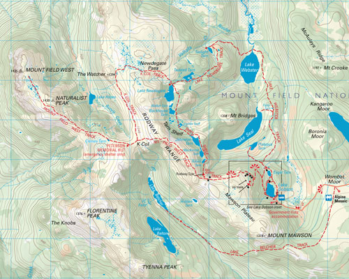

Today's walk was the circuit from the Lake Dobson carpark, along the Tarn Shelf to Newdegate Tarn, lunch on The Watcher, then return on the K Col track along the top of the Rodways. You need to be reasonably fit, with a good sense of balance and a head for heights.

A nice stroll along the Tarn Shelf


with pauses to admire delicate alpine flowers (this one is barely five cm high).


From Newdegate Tarn a steep, rocky climb to the Newdegate Pass and across high moors towards The Watcher. Mt Field West in the distance, left.


Duckboarding is nice for keeping the feet dry. That's The Watcher, the pile of rocks in the middle distance. Naturalist Peak(left) and Mt Field West behind it.


 Approaching The Watcher - and yes, you do have to climb over all those rocks.

One of those little dots on the top is a member of our party


The view from the top is worth the effort. That's the Florentine Valley down there, with the Denison Range behind it.

Where did YOU have lunch today?


Moving right along . . . that's The Watcher, that lumpy bit back there.


Pause for a drink and a breather before tackling rather a lot of rocks.


On top of the Rodway Range we discover a delightful alpine garden overlooking the Tarn Shelf and a tiny glimpse of Lake Webster (right). Another brief rest, then oh look – some more rocks!


After rock-hopping along the top of the Rodway Range we come to the really good bit.

Entering the Lion's Den. Photographs really don't catch the chaotic grandeur of this circle of huge tumbled columns. You really have to be there. Yes, that's snow over there.  


And leaving the Den – same bit of snow


We might be out of the Lion's Den, but there is plenty of anti-pedestrian vegetation between the boulders. And a tiny glimpse of the top of Mt Bridges between the rocks in the centre of the picture.


At last – a clear path, and off in the distance oh joy! Duckboarding! But there's some way to go yet, and a few more boulders to negotiate.


The top of the Rodway ski tow; that may be Lake Belcher in the distance.


Lake Webster from the top of the ski tow


Track junction – the end of the Rodway Range in the background.


Just a few kilometres of easy walking back to the carpark from here. I've discovered muscles I'd forgotten I had. And they're all aching. A day's walking doesn't get much better than this.

The Lion's Den definitely requires a return visit. Next time I'll go up from this end, rather than making the full circuit. Meanwhile, a long, hot bath with lots of bubbly stuff in it then bed.

23 October 2014

Mountain sunshine and Windy Moor

Mt Field National Park has to be one of the most magical places. It has everything scenic – and only an hour's drive from Hobart. There are  picturesque waterfalls and temperate rain-forest in the vicinity of the Visitors' Centre at the entrance to the park and the sixteen kilometre drive to Lake Dobson brings you within easy walking distance of mountain tarns, sheer cliffs, rocky slopes, high moors and alpine scenery. On the way you pass Lake Fenton, source of much of Hobart's drinking water.

I've always thought Seagers Lookout, above Lake Fenton, looks terribly forbidding with its dramatic boulder-covered slopes so it was with a certain amount of trepidation that I set out to climb it on the way to Mount Field East.

I needn't have worried. The track leading up the hidden, not so scary, side is well-marked and, although wet in places, not particularly steep. 


Lake Fenton and the Rodways in the distance


waiting for the rest of the party - the climb gets serious
my favourite scenery - boulders and twisted trees


the gap between rocks is just wide enough to squeeze through

Lake Fenton and the Rodways from Seagers Lookout


morning tea, and a round of the perennially favourite game - "Now what's that mountain?"

Bonnie spots some scenery

and here it is
After morning tea on top of Seagers Lookout we retraced our path to the junction with the Mount Field East track.


At first there was duck-boarding over the muddiest patches, then we reached Windy Moor.


track junction - to Lake Nicholls or up the mountain


the ascent begins

onward and upward

the summit in sight

The structure at the top is the remains of a Sprent cairn constructed during the first survey of Tasmania.
James Sprent (1808-1863) arrived in Hobart Town in May 1830 and opened a public school in Liverpool St. In August 1833 he was appointed temporary assistant surveyor and as part of a trigonometrical survey of Van Diemen's Land set up survey points throughout the south-eastern part of the island. The precise form of these markers depended on available materials, so there were a lot of ten-foot-high stone cairns constructed on rocky mountaintops.

The exact number of cairns built by Sprent is uncertain, many have been partly demolished, and some have modern survey beacons erected on their remains.  The most blatant act of vandalism was the complete demolition of the Sprent cairn on Mt Field East in the mid 1980’s. Less than 12 Sprent cairns remain substantially intact. (ref. Fred Lakin in Tasmanian Tramp, reprinted in Wildcare incorporated newsletter)

An extremely dark green person who believed there should be no man-made objects in a national park took it upon himself to remove Sprent's marker. How he coped with ski-tows, duck-boarding, footbridges and improved paths is a mystery; perhaps the cairn was an easier target.


Sprent's map of Tasmania was completed by 1859 and you can purchase a copy of it from Tasmaps, should you wish to do so: https://www.tasmap.tas.gov.au/do/product/HISTCHART/HISTSPRENT1

After lunch on the summit of Mt Field East where lizards darted over the rocks and we basked contentedly in the warm spring sunshine, we made our way back to the track junction and headed downhill to Lake Nicholls.


view from the top - that's Mt Wellington, on the distant horizon

picking our way back down the mountain


first view of Lake Nicholls (right in the centre of the photo)


day-use hut at Lake Nicholls


From Lake Nicholls we followed the narrow ridge bounding the end of the lake, then it was all downhill back to Lake Dobson road. According to a party member's electronic recording device, we had covered 10.6 kilometres.

It's a great walk - do it!