10 November 2016

As Far Away as Possible

As you probably know, there was some sort of political event on the other side of the Pacific today. Definitely a day to avoid all forms of electronic media, so I headed for the most distant point I could think of.

Hobart is, of course, Australia's southernmost capital city.

If you drive about 130 kilometres south of Hobart you will come to 


From here you walk another ten kilometres or so to South Cape Bay and from there you can see the southernmost tip of Tasmania

South East Cape from South Cape Bay


There is no television nor radio. Absolutely no internet access or wifi; not even mobile phone coverage. A perfect escape. 

We had good weather – warm, but not too hot, and an easy walk through beautiful and varied terrain in congenial company. What more could you want?


Here are some photographs I took down there last year. Forget about politics and enjoy.  


Lion Rock - today's destination; we didn't climb Coal Bluff this time

view from Coal Bluff

South Cape Bay and South East Cape from Coal Bluff


South East Cape from Coal Bluff

03 November 2016

IN WHICH WE FAIL TO CLIMB WETPANTS PEAK

I've returned from the Big North Island, where walks in the ACT consisted of climbing steep hills covered with dry eucalypt forest. Today's walk couldn't have been more different: so nice to be back in the familiar surroundings of a Tasmanian rainforest. Of course, a problem with rainforests is – rain. Optimistically ignoring an unfavourable weather forecast we drove all the way in to the southern forests to the start of the Nevada Peak walk.

Actually, our intended destination was not Nevada Peak but the slightly closer, not so lofty Wetpants Peak, probably named by Tom Stevens of the Forestry Department who surveyed the area in the mid-twentieth century.
You can look up the reference here: https://www.placenames.tas.gov.au/ - just type in the place name. And we didn't drive quite to the carpark, either:


I thought you might like to hear what  the stream beneath the washed-out bridge sounds like:


We had to walk the last half kilometre. 

To our surprise – and theirs – we encountered three snakes curled up together on the side of the road; surely it was not warm or sunny enough for snakes to be out? Of course, by the time I disentangled my camera they were retreating into holes between the rocks, but you can see bits of two of them.


Leaving the carpark, where our cars weren't. Sorry about the rainspot on the lens.


After a short walk on a waterlogged corduroy road we reached the beginning of the track proper.


Depending, of course, on your definition of "track".


morning tea


We began a climb where negotiating the stretches of mud, large pools of water and flowing streams that passed as a track was varied by scrambling over, crawling under and balancing on fallen logs in various sizes and stages of decay. With both hands occupied grabbing vegetation for support, photography was out of the question. Besides, as we gained altitude the weather became more and more inclement, with rain and an icy wind. Through the rain and low clouds we glimpsed snow on Nevada Peak.  

By the time we reached Woolleys Tarn we were tired, wet and cold and had had quite enough, thank you. There were traces of snow there, too.


This is Wetpants Peak. You can see a couple of waterfalls to the left of the picture.

Nobody evinced the slightest interest in climbing it. Even my camera was feeling the damp and refused to work any more. 

So we found a relatively sheltered spot in the forest among some impressive pandani and ate a soggy, hurried lunch before retracing our steps.


The end of a perfect day

and we didn't even GET to Wetpants Peak!

12 October 2016

A week in the ACT - Gibraltar Peak

Every Wednesday three of the ACT walking clubs have a combined walk; this week two Hobart Walking Club members went along as well.

The walk co-ordinator signs the book at Dalsetta car park in Tidbinbilla Nature Reserve before we set out on a walk up the fire trail to Gibraltar Peak.


A bike path leads some of the way upward before we reach a steep fire trail. That's Gibraltar Peak there, right in the middle of the photo.

A feature of this walk is an extensive area of  Xanthorrhoea or grasstree. Lots of them flowering after a fire
We made a detour to Wallaby Rocks. There is no signpost, so you have to know where you're going. These rocks were used as shelters by the Ngunnawal people, and have special significance. A discreet notice by the first overhang welcomes visitors, and asks that we respect the site.


Suitably impressed, we trudged up to the top of the hill. There we rested for morning tea, with a nice view of the Brindabellas, before picking our way down a steep gravelly slope to the foot of the path up to Gibraltar Rocks.


At the beginning of the path a sign informs us that
Gibraltar Rocks is revered by Ngunnawal people as a sacred men's site – a place of teaching for the initiated and a site of cultural lore  . . .  Campfires would have been lit at Gibraltar Rocks to send a message to people entering Ngunnawal Country that the senior men were in residence and the teaching or lore was taking place.

 In 2012 a new track to Gibraltar Peak was opened. It includes these nice granite steps that lead you all the way up.


Brindabellas from the path up Gibraltar Peak
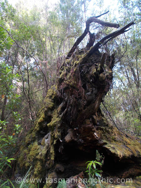
 There appears to have been some burning-off done in patches here and there. We encountered several burnt areas


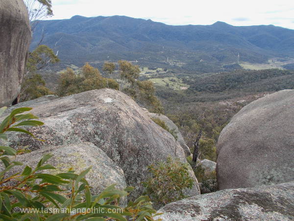
This is the spot for a view

and this is the view.

Off there in the distance we could just make out the Tidbinbilla Tracking Station

There are still these rocks towering above us, waiting to be explored.

A narrow passage between them

– and this is what we just walked under!

the view from the other side is well worth it.
 Rocks explored and views admired, we descended by the new walking track. First we encountered this neat viewing platform.


A very nice, well-built track zig-zags downhill between boulders and rocky outcrops.


charred logs make a stark contrast with the light-coloured granite gravel

After a lunch-stop at the Mt Eliza saddle, where there is a nice circular picnic table, we had a short downhill walk into cleared land and back to our cars.


Another very pleasant walk - great scenery, easy (if slightly steep) walking, fine cool weather and congenial company. What more could a girl want?